
Sharing borderlines with Myanmar in the east, Assam in its western and northern periphery, Arunachal Pradesh in its northeast and Manipur in the south, Nagaland’s blue-hued mountains and emerald landscapes makes it an intriguing world of ancient rituals and a land of tribal richness.
Three parallel mountain ranges running from north to south form a jagged line to create the backbone of Nagaland; these are the Patkai, Barail and Naga ranges from which flow numerous rivers of which the most significant are the Dikhu and the Doyang. The rugged mountainous terrain is highest in Saramati in the Tuesang district, which is 3,840 m above sea level. Japfu Peak at 3014 m is the highest peak in Kohima district.This lush green homeland of the Nagas was formally inaugurated as the state of Nagaland in 1963, making it the 16th State of the Indian Union. Tiger, leopard, elephant, sambar, wild buffalo and bear inhibit its deep jungles.
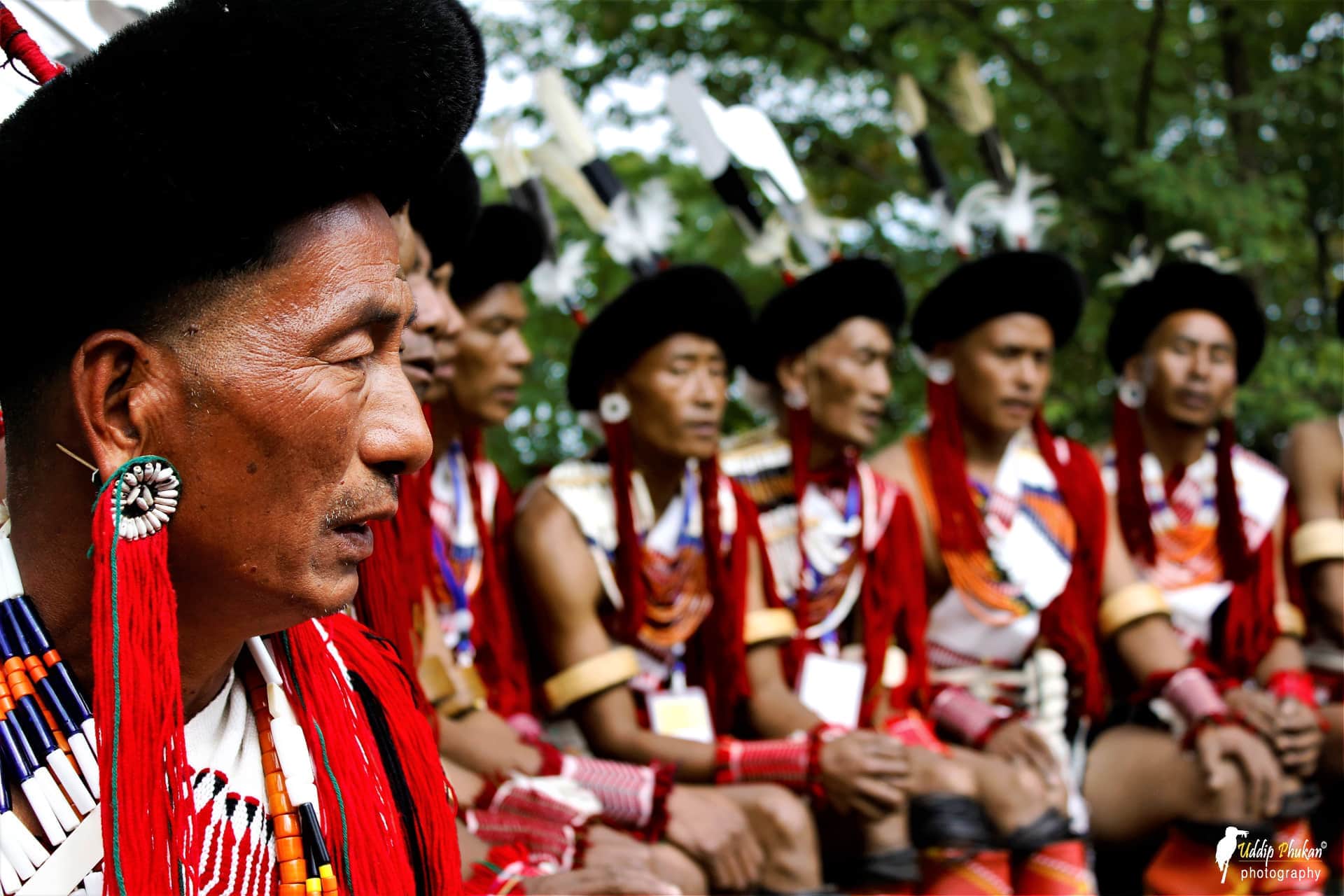
Nagas have evolved into a generic term for many tribal communities in the North East. Of the 32 such tribes, 16 major and numerous sub-tribes spread over Nagaland’s eleven districts; primary amongst them are the Angami, Sumi, Konyak, Lotha, Ao, Chakhesang, Phom, Sangtam, Phom, Chang, Yimchunger, Khiamniungan, Zeliang, Pochury and Rengma, each with their own distinct culture and lifestyle. All Nagas were originally animist by tradition, but over time most of the population embraced Christianity under the influence of American missionaries.
The Nagas were also recruited by the English as labour corps to serve in France during the Second World War. They were highly commended for their loyalty and bravery. Naga society is a richly woven unit where ancient tenets still play an important role even in today’s contemporary life. This land of myths and festivals, brave warriors and a rich cultural heritage welcomes all those who have a heart for adventure.
Nagaland Tourism Tips
How to go to Nagaland ?
Dimapur airport has flights from Delhi and Guwahati and also has the nearest train station.
Kohima, the Capital of Nagaland, is connected by road to Dimapur, Imphal, Guwahati, Shillong and Kolkata (Calcutta).
What is the weather in Nagaland ?
In summer, temperature ranges from 16°C to 31°C and in winter from 4°C to 24°C.
What is the best time to visit Nagaland ?
The monsoon is happening from May to September. Hence the ideal time to visit is from November to April.
Know more about Nagaland
Kohima
Nested at a height of 1200m, Kohima is the Capital of Nagaland and the territtory of Angami Naga Tribe. Kohima name comes from Kewhi, a local flower. More than its exotic flora and fauna, Kohima has an incredible, yet almost unknow, history.
Explore the exotic Keeda Bazaar (insect market) where stalls are covered of eels, frogs, snails and skewers of worms and other crawlers. Fainthearted refrain !
Located on Bayavu Hill 2 km from the center, the Nagaland State Museum offers an exhibition on the evolution of Naga culture. One can discover the tribal habitat as well as a collection of rare objects belonging to the 16 main tribes (motifs on fabrics, precious stones, necklaces, traditional outfits …) It is also installed the replica of a Morung Naga, showing thus the differences of architecture between the tribes. Musical instruments in bamboo and buffalo horn are also shown here.
The War Cemetery is a historic site, reminiscent of soldiers who fell during the Japanese invasion during the Second World War. This cemetery has more than 1430 graves (1,100 British, 5 Canadian and 330 Indian graves), for which a commemorative bronze plaque is dedicated to each soldier.
This cemetery retains two crosses at the top and bottom of the field. On the cross at the top, it reads, “Here, around the tennis court of the Deputy Commissioner lie men who fought in the battle of Kohima in which they and their comrades finally halted the invasion of India by the forces of Japan. in April 1944”. The other cross reads “When you go home, we are fed up today”. This cemetery is located on the Garrison Hill Battlefield and the Commonwealth War Graves Commission is in charge of its maintenance.
Mary Help of Christians Cathedral is one of the largest churches in northeastern India and a place that characterizes Kohima. In 1948, missionary Sisters arrived in Kohima to serve in one of the civilian hospitals in the area. At the same time, the Church begins to spread Christianity. Following the success achieved, two separate dioceses for the states of Manipur and Nagaland were created.
Since then, various services offered by this church such as educational and social services have spread throughout the region. Located on the Aradhurah Hill, this church is also known for its architecture, which reflects the mix of Aboriginal and modern art.
Kisama Heritage Village is located 10 km from Kohima on the foothills of a hill. This is the testimony that Nagaland is a land rich in culture and tradition. To discover this unique culture, what is more representative than to visit a model village where are built the different houses of all the ethnic communities of the state ? Traditional thatched roof houses and carved wooden columns plunge you into the past.
This huge complex also houses a museum that houses artifacts from the Second World War, a traditional bamboo assembly hall, a food court and an amphitheater, site of the famous Hornbill Festival which takes place every year the first week of December : See the itinerary for the 2020 Hornbill Festival.
Dzukou Valley & Japfu peak
Located at 2,450 m above sea level, the Dzukou Valley straddles Manipur and Nagaland. This valley is a photographer’s paradise and also a wonderful picnic spot with its flower beds and dwarf bamboos. The valley takes its name from the Mao meaning “cold water”, referring to the many springs that cross the valley. It has not undergone any modification by the man and changes with the seasons.
The second highest peak in Nagaland, the Japfu peak rises to 3050 m altitude. It is located 15 km south of Kohima and particularly attracts hikers. The path to the summit is well marked and the view from the top of the peak is breathtaking.
Another hidden wonder of the valley is the giant rhododendron. Listed in the Guinness book record, it is 130 meters high and almost 4 meters in circumference. We must still consider 5 hours of hiking to admire!
Nagaland by Foot is a perfect route for hikers wishing to discover a rural and authentic Nagaland.
Khonoma
The village of Khonoma is located 20 km west of Kohima. The village offers a breathtaking view of the beauty and natural diversity of Nagaland. The village configuration is a private sanctuary and is managed by the community – Khonoma Nature Conservation and Tragopan Sanctuary (KNCTS), a unique community initiative for the conservation of wildlife and the environment.
A guided tour is the best way to discover the 700 year old village. Go past the akharu (carved wooden door), the Mithun horned houses and other animal skulls, the huge rice beer fermentation vats, oversized rifles and giant ladle pots that seem straight out of them. Gulliver’s Travels.
The village is divided into khels (residential areas) of various clans with a kuda (fort), defense place, surrounded by morungs (residential buildings). Do not miss the hwe of Khwe (engraved stone tablets) built in honor of the ancestors who fought in the Anglo-Naga battles at Semoma Fort. They were described by the British as the strongest warriors in the Northeast.
In the village, it is possible to stay at the inhabitant to discover more about local lifestyles, while having his private space.
Dimapur
Dimapur mainly serves as the main entry point into Nagaland. It is also the largest city and the commercial center of the state. Nature lovers will be captivated by the scenic landscape of the place and history buffs will visit the 10th century Karachi ruins.
Discover here the many example itineraries in Nagaland :